Pakistan’s 2025 monsoon has unleashed some of the country’s worst riverine and flash flooding in decades, with the brunt felt across Punjab, Sindh, Khyber Pakhtunkhwa (KP), parts of Balochistan, Gilgit-Baltistan (GB) and Azad Jammu & Kashmir (AJK). Below is a clear, region-by-region rundown of the hardest-hit areas, what’s driving the devastation, and why these places remain at high risk as the season continues.
Punjab: The Sutlej–Ravi–Chenab belt
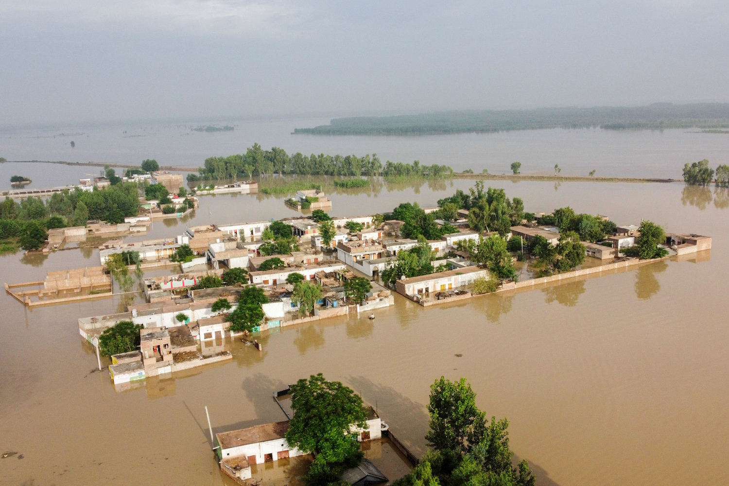
Punjab has been the epicentre of 2025 flooding. High flows on the Sutlej, Ravi and Chenab—exacerbated by heavy monsoon rains and upstream releases—have inundated vast tracts of the agricultural belt. Districts repeatedly flagged include Kasur, Okara and Pakpattan along the Sutlej; Sialkot and Gujranwala along the Chenab; and low-lying localities on the Ravi’s floodplain. Authorities have undertaken mass evacuations and even controlled embankment breaches to protect larger cities such as Lahore, but many villages remain under water and cut off. The scale of displacement and crop loss in this breadbasket region has been severe, and additional rainfall pulses threaten to prolong the crisis. AP NewsReutersDawn
Sindh: Rising Indus levels from northern inflows
As swollen northern rivers feed into the Indus, Sindh faces a delayed but dangerous crest. Early warnings have focused on Guddu and Sukkur barrages, where high flows are expected as water from Punjab merges into the main stem. Districts such as Kashmore, Ghotki and Shikarpur—already vulnerable due to embankment weaknesses and settlement patterns on the floodplain—are on heightened alert. Downstream, low-lying katcha (riverine) areas face the dual risks of prolonged standing water and isolation of communities. Given the 2022 precedent, contingency plans for livestock evacuation, seed/fertiliser support and temporary shelter are crucial now. ReliefWeb
Khyber Pakhtunkhwa: Cloudbursts and mountain flash floods
KP’s northern districts have endured deadly cloudbursts and fast-onset floods, a pattern linked to steep terrain, deforestation and more intense rainfall events. Buner and Shangla have been repeatedly named among the worst-hit, with roads, bridges and hillside communities bearing the brunt. Further north, parts of Swat and Chitral remain vulnerable to landslides and glacial lake outburst floods (GLOFs). The rapid onset nature of these events overwhelms local response capacity and increases risks of secondary crises—injuries, waterborne diseases and shelter shortfalls—especially where access roads are washed out. OCHAAl Jazeera
Balochistan: Sparse services, wide-area impacts
While flood volumes are often lower here than along the Indus corridor, Balochistan’s challenge is geographic spread and limited infrastructure. Flash floods in typically arid catchments can sever highways, isolate valleys and damage irrigation systems, compounding the province’s chronic water stress. Relief items and medical teams take longer to move, and with many communities reliant on smallholder agriculture or livestock, even short-duration inundations can turn into prolonged livelihoods crises. National situation reports list continuing relief distributions in select districts, underscoring persistent need for shelter, mosquito nets and basic NFIs (non-food items). National Disaster Management Authority
Gilgit-Baltistan & AJK: Glacial and orographic hazards
In the high mountains, extreme rainfall colliding with fragile glacial systems drives a different flood profile: sudden torrents, landslides and debris flows. Narrow valleys funnel water and rock into settlements and along critical road links (including CPEC corridors). Scientists and media have highlighted how accelerated glacial melt and reduced forest cover magnify flood peaks and sediment loads, raising long-term risk even in years with “average” rainfall. Targeted early warning, slope stabilisation and micro-hydrology projects are vital alongside humanitarian response. Al Jazeera
Urban flash floods: Karachi and other cities
Major cities have also taken hits from cloudbursts and overwhelmed drainage. Karachi’s low-lying neighbourhoods and informal settlements are perennially exposed when intense downpours coincide with high tides or clogged nullahs. Similar urban flash-flood dynamics have been reported this season in Sialkot and parts of Lahore, disrupting transport, power and healthcare access. Investing in stormwater infrastructure, solid waste management and green corridors is as much a resilience strategy as a civic upgrade. Arab NewsDawn
Humanitarian picture: Displacement, health, and crops
Countrywide, the humanitarian footprint is large. Evacuations in Punjab alone have reportedly reached into the hundreds of thousands, with relief and medical camps set up by authorities and civil society. National and international agencies warn of surging waterborne disease, skin infections and malaria in crowded shelters. With crops and stored grains destroyed across floodplains, immediate food assistance and seed support will be key to preventing a secondary food-security shock. Recent updates from OCHA and NDMA detail ongoing distributions (tents, ration bags, blankets, mosquito nets), but gaps remain against needs as waters linger. AP NewsOCHANational Disaster Management Authority
Why these areas are hit hardest
Three factors explain the geographic pattern: (1) Hydrology—Punjab and Sindh lie along major rivers where monsoon pulses and upstream releases converge; (2) Topography—KP, GB and AJK’s steep terrain turns heavy rain into destructive flash floods and landslides; (3) Exposure and systems—rapid urbanisation, embankment encroachments and deforestation reduce absorption and slow drainage, while poverty pushes households to settle in high-risk katcha zones. Climate change amplifies extremes, stretching response capacity and recovery timelines. Al Jazeera
What to watch next (early September outlook)
As late monsoon systems cycle through, watch: (a) the flood crest moving down the Indus into upper Sindh (Guddu/Sukkur); (b) fresh rainfall bands over already-saturated districts in central and northern Punjab; and (c) flash-flood alerts in KP’s northern valleys. Preparedness steps—pre-positioning medical kits, vector control in camps, repairing rural access roads and securing fodder for livestock—will soften the blow of any further surges. ReliefWebDawn
Bottom line: In 2025, the top affected areas span the Sutlej–Ravi–Chenab corridor in Punjab, the Indus floodplain in upper Sindh, the cloudburst-prone northern districts of KP, and vulnerable pockets of Balochistan, GB and AJK. Rapid relief, coupled with resilient infrastructure and ecosystem restoration, is essential to break the cycle of flood–rebuild–flood.